The world changed in the past 60 years. Many improvements in technology have shown how amazing our minds are. We have found different ways to create solutions to our world, making it easier and more efficient. One of the most useful improvements in technology trending right now, is the "LIDAR" Light Detection and Ranging . Lidar originated in the 1960s, shortly after the invention of the laser, but it was not until after 1971, during the Apollo 15 mission, that we realized how accurate and useful Lidar systems are. Astronauts used this laser altimeter to map the surface of the moon.
| Rotating LIDAR sensor |
LiDAR uses the laser to illuminate a target and then analyze the reflection, the narrow laser makes possible to map objects with a high degree of resolution. But why if LiDAR has been around since the 70s, was it not used during the past years. The answer is it was not easy to construct in small sizes, the cost was really high and the complexity of the technology limited the applications (mostly government). However, due to the big advances in laser detection, computational speed, and memory storage, we now can use this technology for commercial applications.
 |
| LIDAR Data |
So where can we apply this technology? The answer is broad. Applications include:
- Agriculture, Archaeology,
- Autonomous vehicles, Biology and conservation,
- Geology and soil science
- Atmospheric remote sensing and meteorology
- Law enforcement, Military
- Mining
- Physics and Astronomy
- Robotics
- Spaceflight
- Surveying
- Transport
- Wind farm optimization
| LIDAR terrestrial |
 |
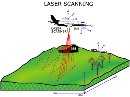
| LIDAR Aerial |
Topographic maps were usually created by Photogrammetry, the science of making measurements from photographs. The output is typically a map, drawing, measurement, or a 3D model of some real-word objects or scene. Many of the maps we use today are created with photogrammetry and photographs taken from aircraft. So why choose LiDAR to create topographic maps instead of Photogrammetry?
 |
| Mobile LiDAR survey |
LiDAR is a perfect tool for any Engineer. It can be used to have a 3D model for objects, areas, or any structure. The models can be uploaded to different computer software and used to create and develop new designs. Engineers can work in a specific area of construction and create designs quicker and smarter.
| LiDAR in Machine |
LiDAR uses a lot of memory data information, and that is one of the reasons many users of LiDAR have to use Terabytes (TB) = 1000 Gigabytes (GB), finding ways to create more memory for computers will help us to create more applications for this technology. LiDAR will become more and more popular in the future, and I am sure we will find more applications of this technology in many other fields.
References:
- [Rotating LIDAR Sensor], retrieved on October 22th, 2015 from http://www.roprodesign.com/projects/mechanicalprojects/lidar/
- [LIDAR data], retrieved on October 22th, 2015 from https://www.leidos.com/sites/default/files/imported/geospatial/images/lidar1.jpg
- [LIDAR terrestrial], retrieved on October 22th, 2015 from http://www.cartodata.com/technologies/lidarterrestre/
- [LIDAR aerial], retrieved on October 22th, 2015 from https://www.e-education.psu.edu/geog481/l1_p3.html
- [LIDAR aerial], retrieved on October 22th, 2015 from https://www.e-education.psu.edu/geog481/l1_p3.html
- [Mobile LiDAR survey], retrieved on October 22th, 2015 from http://www.mobilelidar.com/2013_09_01_archive.html
- [LIDAR in Machine], retrieved on October 22th, 2015 from http://www.equipmentworld.com/volvo-ce-unveils-siteaware-lidar-camera-combo-gives-equipment-operators-360-degree-vision-photos-video/
